Thumbnet.net header graphic

Thumb National BankErrers Home Furnishings Tina Seley Harbor Beach
Huron PropaneThumb Area TransitCourtney ManorPort Austin State BankHarbor Beach Community Hospital Walk In Clinic
Bad Axe OrthodonticsShaw AgencyBresky Siding and BuildingRolands Paint And More

Area News Headlines

These news headlines brought to you by these fine sponsors:

Advanced Auto Glass East Side Tire A-1 TRUCK Lundy Financial Services A&B Auto Repair Morrel Equipment Osentoski Bad Axe Tec Fiber Internet Services ABC Oil and Gas Tri-Country Equipment AVCI.net JW Hunt Scheurer Hospital Maurer Electric
Osentoski Bad Axe Tec Fiber Internet Services ABC Oil and Gas Tri-Country Equipment AVCI.net JW Hunt Scheurer Hospital Maurer Electric Advanced Auto Glass East Side Tire A-1 TRUCK Lundy Financial Services A&B Auto Repair Morrel Equipment
JW Hunt Scheurer Hospital Maurer Electric Advanced Auto Glass East Side Tire A-1 TRUCK Lundy Financial Services A&B Auto Repair Morrel Equipment Osentoski Bad Axe Tec Fiber Internet Services ABC Oil and Gas Tri-Country Equipment AVCI.net
A&B Auto Repair Morrel Equipment Osentoski Bad Axe Tec Fiber Internet Services ABC Oil and Gas Tri-Country Equipment AVCI.net JW Hunt Scheurer Hospital Maurer Electric Advanced Auto Glass East Side Tire A-1 TRUCK Lundy Financial Services
Advanced Auto Glass East Side Tire A-1 TRUCK Lundy Financial Services A&B Auto Repair Morrel Equipment Osentoski Bad Axe Tec Fiber Internet Services ABC Oil and Gas Tri-Country Equipment AVCI.net JW Hunt Scheurer Hospital Maurer Electric


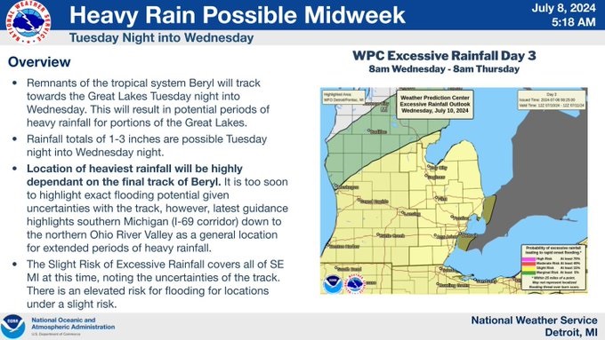
Tropical Storm Beryl's Remnants to Bring Heavy Rain and Storms to Michigan

Deena Bruderick

Mon, 08 Jul 2024 10:12:33 EDT


click on the picture to enlarge


The National Weather Service in Detroit has issued a hazardous weather outlook for Southeast Michigan, including the counties of Bay, Huron, Saginaw, Tuscola, Sanilac, Lapeer, St. Clair, and more.

Isolated to scattered thunderstorms are expected this afternoon and tonight as a weak frontal boundary moves south into the region. These storms could bring brief periods of heavy rain and gusty winds.

Looking ahead, thunderstorm chances will continue into Tuesday as the front stalls over or near the area. There is an increasing likelihood of significant rainfall from Tuesday night into Wednesday due to the remnants of Tropical Storm Beryl. If Beryl's remnants impact Southeast Lower Michigan directly, widespread heavy rainfall could occur, leading to a potential for flooding.

Residents are advised to stay updated on the latest weather forecasts with the Precision Weather updates on Thumb Broadcasting and to take necessary precautions to ensure safety during these weather events.


Copyright © 2010 - 2024 Thumbnet.net and Thumb Broadcasting Incorporated

An equal opportunity employer EEO Report

Privacy Policy | WLEW-FM Public File | WLEW-AM Public File | WHST-FM Public File | FCC Applications | Official Car Sweepstakes Rules

WebReady powered by WireReady® NSI

The Pasta House PIGEON CHAMBER McVey Insurance D&m Cabinet GREENSTONE FARM CREDIT SERVICES Peppermill Old Time Tree Service Burkhard Heating and Cooling